[The Setup]
Sitting in the parking lot of a Burger King in Dalton last August, wishing I could enjoy the beautiful fall weather, I knew I would be back. I knew that one day, I would ride by that spot and begin the final, unknown (to me) stretches of this blindingly sadistic route.
Four months prior to that, I stopped much shorter on the route when my ride partner, Kinzer, developed a very bad knee injury. At the time, I had relatively good fitness and, although the course is incredibly challenging, I felt like I was able to suffer through and would have been fine otherwise. Perhaps this [inflated?] sense of self contributed to me hardly riding at all during the intervening months, and when combined with bad weather fortunes, conspired to tear me down to a broken, ripped, shell of a man, force-feeding himself a croissan’wich™. This was not a mistake I would make again.
A rough date was set of early May-ish for our final revenge.
In the meantime, I did a few confidence building rides in Florida, including a respectable finish in the CFITT, and a very enjoyable 4 day veteran tour of the HuRaCaN.
Spring drew closer and I began adding hours to my weekly riding totals, hoping to build a base that would power me through the mountains. My main goal was to acclimate to my saddle, and work out any issues that might cause a repeat of August.
Another goal I decided to attempt on this ride was to use a portion of it as an experiment in preparation for riding the Colorado Trail, which has a long back country stretch with no services (other than hopefully ground water). As I will need to carry all of the food I will need to cover that distance, it seemed reasonable to attempt to do the same for a portion of the TNGA (especially since, if I screwed up, the consequences here would be less severe than in the high back country of Colorado). It’s not perfect, as I can’t simulate the altitude, but otherwise the statistics add up fairly similarly: 200 miles and around 35,000ft of climbing.
With the start date approaching, Kinzer brought up the idea during a planning meeting of departing from the border the night before the morning of our intended start and essentially pregaming some miles. The rationale went like this: there is no good camping spot at the start; there are no technical trails for the first 20 miles or so and numerous places (once in the forest) to camp; so why not get a few hours head start and have a nice place to get some [hopefully] more restful sleep? This plan would add to the ride’s total elapsed time (the official measure of how fast the rider completed the route) but since neither of us had any notion that we would be breaking course records, the plan actually seemed like a really good idea.
Most of my gear has been dialed over the past year and a half, the only major changes to my setup for this ride would be the use of a 27.5×3″ tire in the front (standard 29×2.2″ in the rear) and the changeover from SRAM to a Shimano Di2 drivetrain.
Di2 is an electronic shifting system. This has some advantages and some compromises over a traditional sprung, cable-actuated system. But the short of it is that I would have two shifters capable of controlling one derailleur (redundancy in case of damage in a crash), and would not have to worry about cable housings getting gunked up with mud and such, and all of my pre-ride testing pointed to the battery lasting many times longer than the required span of the ride, so even though I would be bringing the battery charger, it should remain buried at the bottom of my bag the whole ride. Some of my thoughts on using Di2 for bikepacking can be found over at Toecutters.com.
Even still, I geeked out over what gear to bring, and what food to pack and how to pack it. For the curious, you can get the full pack list here. I watched the weather obsessively, but when the final morning came, there was nothing left to do but throw the bike on the back of the car and head up to the border.
[Day One-ish]
Once at the border, Kinzer and I strapped everything to the bikes, buttered our chamois and kissed goodbye to our respective ladies, committing to not seeing them again until we had made it to Alabama.
The ride starts on a gradual paved climb, there’s a roller or two, but for the most part it’s a nice easy way to spend the first couple of miles. Soon though, you reach the first turn, the pavement ends and the real climbing begins.
These roads seem to climb forever, when they finally do turn down, it’s only momentarily and the surface is either loose or rutted so you can neither relax nor enjoy the descending. At one point you’re climbing what on any other ride would be considered a “the Wall”, you burn a whole book of matches just to get to where you think it levels out, only to be confronted with a fork: the left fork goes down; the right fork is somehow, steeper than what you just climbed, but is blocked by a guardrail and a “Road Closed” sign. Easy, you go left right? Wrong. Rule #1 of TNGA: if there’s a turn on the road, the correct choice is “up”.
At this point you look down at your GPS and see that you’ve only gone maybe 8 miles! Better pick up some more matches at the next town.
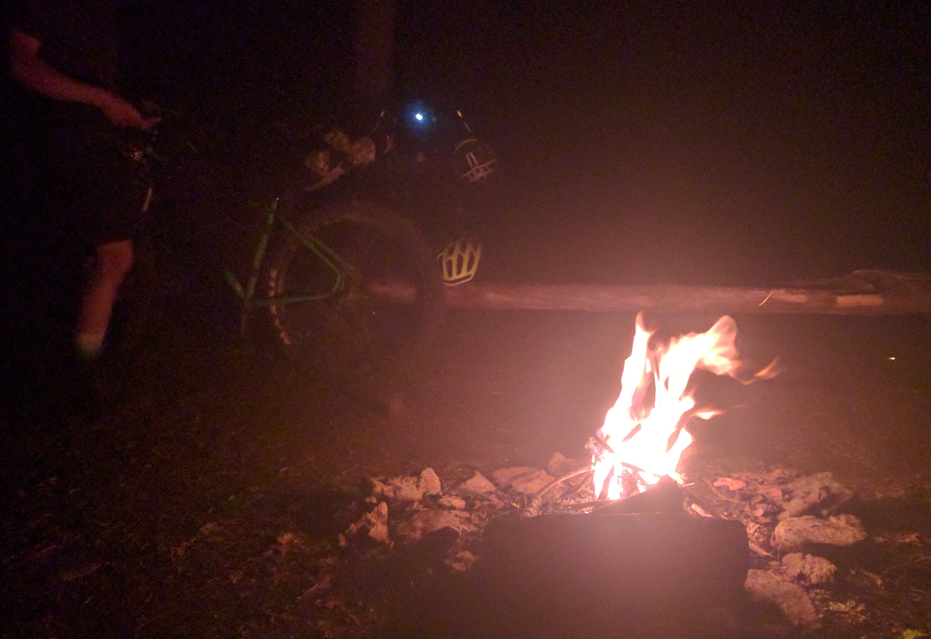
About 21 miles in, the roads end and you reach the Darnell Creek Horse Trail. The ‘trailhead’ here is a nice flat spot with a fire ring, soft ground, and ample deadfall for building a fire. Pregaming verdict: Win!
We woke up in the morning, rested and dry, ready to shred some singletrack. Darnell Creek is a horse trail, that is clearly not traveled by many horses (hooray!). There’s a small bushwhacky spot in it, and then it drops down a sideslope through a rhododendron tunnel that’s so tight, you end up smacking your helmet even with your ass so far off the back of the saddle that you’re practically scraping the tire with your balls. Eventually it levels out and you cross several streams, one of which is at a beaver dam that will steal your shoe if you’re not careful.
With the exception of the 20 miles of mostly flat, rolling paved road that take you into Dalton, there are two types of roads on TNGA: impossibly steep or rutted forest roads (some may have been closed to vehicular traffic for some time); and more mellow, but populated roads (maybe paved, maybe nice hardpack dirt). The former will bleed you dry in obvious ways. The latter surprises you, because on paper they should be recovery roads, but in practice this is where TNGA keeps all of the #dogsprints. Just when you think you can catch your breath, you’re up out of the saddle attempting to outpace a pack of someone’s dogs, frothing at the mouth to sink their teeth into your leg or wheel. Good times.
Protip: Keep a water bottle with an open mouth so you can quickly ‘spray’ the lead dog, this seems to give the best results for the lowest energy expenditure.
Eventually you make your way to the Tallulah River at Charlies Creek Road, and do one of (if not the) longest rideable water crossing in the state. Traveling first, about 40 feet out into the water, and then turning almost 90 degrees to the right to then go another 100+ feet upstream to the takeout. Then the fun is over and you’re back to climbing on dirt roads for a long long time.
The route takes you down to lake Burton, up and over Addis Gap, then up Tray Mountain to Tray Gap. I’ve heard people speak of this as the most miserable climb of the route. I’d have to disagree. It’s perhaps the longest, and it’s unpaved, but it’s not particularly hard. I never felt like I had to bury myself at any point or that it droned on the way Hogpen does and it’s certainly all rideable, unlike the climb up to Rocky Mountain by Stanley Gap or the never-ending hike-a-bike up Strawberry Mountain.
Regardless of how you feel about the climb up to Tray Gap, I can’t imagine there are too many people who feel warm and fuzzy about the drop down into Helen that follows.
You start off on Tray Mountain Road heading south (not west, which is probably a fun fast descent), down a very [large] rocky, eroded roadbed. The road is bench-cut into the sideslope of the mountain so there’s a sheer drop on one side and a wall on the other. Due to wheel erosion, there is occasionally a ‘curb’ left on the outside which is smoother than the road surface, but it’s often overgrown with saplings and can be even more treacherous (because of the consequences of falling off) than taking a bad line through the rock garden of a road. Eventually the road starts to level out a little, rock gives way to clay/mud and you wind up at an intersection.
Left goes down off the mountain, right goes up, a barely rideable up, for about a quarter mile, then levels off and the road disappears. Both choices are wrong.
The correct choice (leap of faith) is to go straight, into the brush, towards a pile of dirt left by the dozers during road construction. Ride over this pile and you will unlock the secret “road” which leads down into Unicoi State Park. It used to be a road bed at least, it’s a 8-10′ wide bench cut in the sideslope of the mountain, only this time, because it hasn’t been used (evidently by anyone other than TNGA riders) it’s incredibly overgrown. Deadfall, poison ivy ground-cover, and man-heads (the adult-sized relative of baby-heads) which wind up here because it’s the first horizontal surface falling rocks encounter after being flipped off the top by hogs or bears looking for snacks. The leafy ground-cover hides all of the loose rocks, and in places obscures the water breaks, which have eroded to the point of having a near vertical approach. Towards the bottom, the trail does finally come to resemble more used singletrack and allows you to pick up some speed, but until then, you just pick and pinball your way down the side of the mountain.
To give an idea to readers, check out the Strava segment below. The top time as of this writing stands at 41:24. That’s barely over 10mph… on a 2100ft descent!
After you pop out in the middle of Unicoi State Park, you start the the Gaps section of TNGA, riding up Hogpen and Wolfpen, with a fun little gravel connector on Hatchet Creek (where there is a really stunning set of falls). Slow miles. But if you time it right, you’ll get to these in the evening/night, when it’s easy to cover big road[ish] climbs.
I’ve found that climbing in the dark is easier on the psyche since you’re never faced with coming around a corner and seeing some impossibly long stretch of road winding off into the heavens. You only see the yards ahead of you. The tradeoff is that you won’t get the views (a coveted rarity in the Blueridge region).
Once you get to the top of Wolfpen Gap, you can pat yourself on the back, you’re done with the road climbs… So follow rule #1, turn up, and begin the climb up Duncan Ridge to the top.
Which brings me to one of the lies of TNGA: “We’re at the top”/”It’s all downhill from here” The other big lie, in case you’re wondering is the similar but unique: “The hard part is over”.
This is where we bailed last year when Kinzer’s knee looked like someone had taken a baseball bat to it. I rode up this climb in August, and I remembered there being very little on this stretch of road. Kinzer was under the impression that there would be a campsite at the top of the climb. I had no memory of anything up there, but it did appear that the hiking trail (Duncan Ridge) intersected the road near the top on the map, so worst case, I reasoned, we could at least get off the road to sleep. Up-and-at-them!
As we got to the top, Kinzer spotted the pulloff, a 120 degree turn on something like a dirt driveway, which went on for 20 yards to a very nice campsite! Time to build a fire, and grab some sleep. It’s been a big day.
[Day Two]
After a decent night’s sleep, and a cup of coffee, it was time to break camp and enjoy some of the easier miles on the course. The gravel trends down for about 10 miles at this point (not a bad way to start the day). At the bottom is a store on Hwy 60 that apparently has the best something-or-other. It didn’t matter because we got there too early for it (I’d gotten there too late back in August… c’est la vie)
As Kinzer restocked, I sat at the picnic table and ate some food out of my bag, organized my thoughts, and continued my time-honored tradition of not s#!tting in the woods by helping myself to their facilities.
The road rolls on from here, sometimes gravel, sometimes paved as you work your way towards the Aska Rd trails and Stanley Gap. There is one steep paved climb on this stretch, but otherwise it was so unremarkable that I had committed none of it to memory from August. That’s not to say it’s easy. The road into Dalton is really the only easy on the route and I remembered it well. This stretch is just, unremarkable.
When you get to the trails, you’re treated to something like 3k of climbing over just 6 miles, with a short descent thrown in here or there just to keep you believing the first lie of TNGA. The climbs are populated by numerous root/rock ledges, which, if they weren’t already on impossibly steep sections of trail (for a loaded bike), would definitely force almost any rider off their bike. Count on a good chunk of hike-a-bike through here. You’ll know you’re at the top when you get to a rocky-rooty ledge that elicits a “no-f’ing-way”. It’s maybe 4-5 feet vertical and will require you to lift your bike and plan your steps to get over.
High-five! It’s time for another screaming (but all too short for what you just earned) descent… back down to the road you started on… about half a mile up the road. wonky-faced-emoji
Drop down to the ‘town’ of Cherry Log, pass under the highway, turn right and, if it’s Thursday-Sunday, continue straight, back under the highway for some excellent bbq at the PinkPig. Lucky for us (and my plan to make it to Mulberry without support), it was Monday… no Pig for us. sad-faced-emoji
Head off into the country roads west of Blueridge, until you get to GA-2. Here you start the climb up to Watson Gap. The road gets steeper and less paved as you go. Joy! Wind your way up the mountain, until eventually you pass the gap, climb a little more passed Dyer Mountain, then drop down to Dyer Gap, hang a right round a switchback and go straight onto the Southfork trail. Finally, back to singletrack.
After a quick spin here, you get to what will be your guiding blaze for almost the entire remainder of the ride, the turkey foot of the Pinhoti!
I believe this is called (by some?) P0. Unlike other Pinhoti segments, there’s a fair bit of ‘grassy’ doubletrack, which climbs back up to the road you left moments ago. Think of it like riding through an uncut grass field, up a steep hill… until you remember why you hate riding through an uncut grass field. And then continue for another mile or so.
Once back on proper gravel road, you make some mountain traverses eventually ending at Potatopatch Mountain, where you hang a left and pick up the Bear Creek Trail.
Bear Creek is one of the few exclusively fun (even loaded) trails on this route. You’ve already done all the work to get to the top of it, and all it does is go down. If you’re brave (and confident that you’ve properly secured your load), there’s plenty of air to be had as you work your way down to P1 (yep, more Pinhoti).
Fun’s over kiddies, time to climb some more. P1 gets you to your standard, run-of-the-mill Pinhoti. Steep, roots, rocks, and typically rather damp (you are in a temperate rainforest btw). P1 links to P2 which takes you to Mulberry Gap Road (it may be named differently on your map… too bad).
From here you can either continue on to P3, or shoot up (literally, not figuratively) the road to the Mulberry Gap Mountainbike Get-a-way, where you will find camping, cabins, supplies, dinner/breakfast, showers, even hottubs (if you’re so inclined).
We dropped in super late, but Andrew had waited up for us to make sure we got in ok. I’m terrible at small talk, even when I haven’t just blasted myself for two days, so I must have come off as sociable as a traffic cone. Maybe it was the sirensong of the showers calling to me (yeah, let’s blame it on that), but after standing around awkwardly for way too long (because there’s an acceptable amount of awkward standing…), I made my way over to the shower, cleaned up, dried off, and went to our cabin. I grabbed some food out of my bags with the intent of eating some dinner, took maybe two bites of something then promptly passed out. Out out.
[Day Three]
We had been crushing the early starts and the late finishes for the last couple days, so waking up here, and waiting around for some breakfast, although slightly anxiety-provoking (you want to keep your momentum going and every minute you stand around is another minute you’ll have to tack onto the end of your riding that day), was totally worth it.
After eating, we stocked up, said our goodbyes and then headed back to the course for, you guessed it, more climbing!!
P3 goes up (big surprise there). But there is a nice little descent towards the top of it. There’s some water breaks that you can grab some good air on (too much if you’re not careful; ask me how I know). I decided to keep wheels firmly planted on the ground this go-around and was rewarded with a big stick in my wheel which ripped a spoke right out of the rim. The head of the nipple failed, not the spoke (to be clear). This is important because it meant I had a small piece of brass stuck between the inner walls of my rim… well, not stuck, it was free to rattle about… for the next 110 miles. fml-faced-emoji
After another kick, you come out on a paved road, dog-leg down (figuratively, not literally) the road to P4/P5 (I don’t know the ‘official’ difference) and beyond. Once you pay your dues climbing to the top, there are some good free miles to be had as you work your way over to the final drop (and it’s an awesome one, btw) into Dennis.
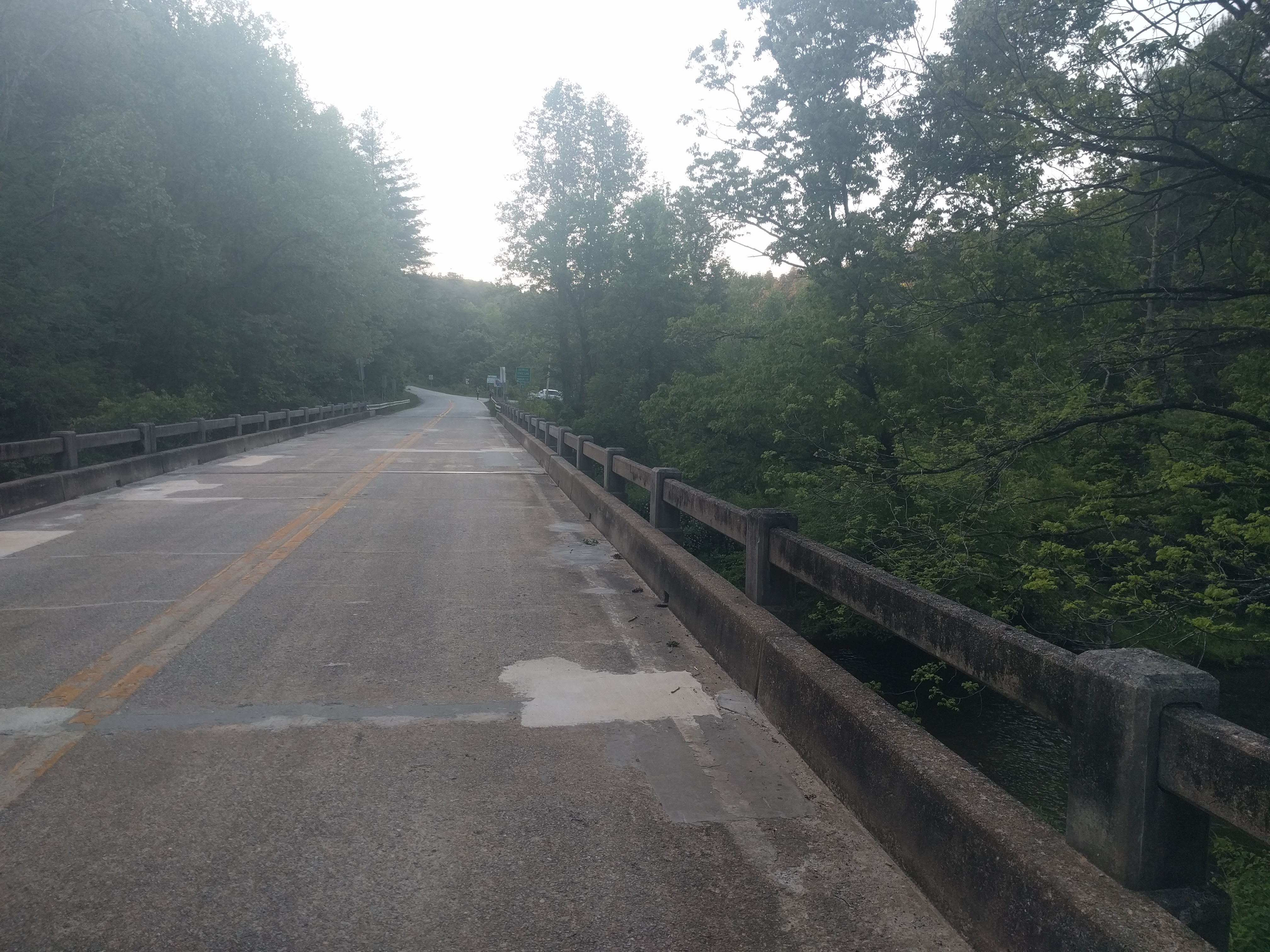
Congratulations again! You’ve just made it to the end of the Blueridge geologic region of GA! You now get to spend about 25 miles on pavement, on the Piedmont Plateau. Smooth, fairly flat road riding as far as the eye can see.
As you near Dalton, you start getting little peeks here and there of the infamous Dug Gap radio towers. A welcomed sight when spotted during the Snake Creek Gap Time Trial Series, they are anything but on TNGA. The closer you get to them the more you realize how far up they are (and what they mark the beginning of). In the meantime though, stop in at any number of places in Dalton, it’s the last stop before the border and the only real city on route. We chose Kroger as our one-stop supply shop.
The only thing worse than going to the grocery store hungry is going to the grocery store after you’ve buried yourself on a bike ride through the mountains for three days. So it helps to have a [pre-decided] strategy when going into a grocery store. Otherwise you’ll end up wandering around like a zombie, maybe you’ll grab some stuff but it won’t be everything you need and a good chunk of it may be total crap that you just end up carrying on the bike for the rest of the trip. My strategy is to go in and meet my immediate needs: get a meal and something to drink; sit down outside and eat/drink; once I’ve recovered a bit, go back in and get what I really need (food, in this case sunscreen, and whatever else).
Protip: Whenever you’re in a town, it’s nice to stop at a place that sells prepared (preferably packaged/wrapped, i.e. “fast”) foods. Dropping a burger or a chicken sandwich in your bag for later that night or the next day (it’ll keep, trust me, and try not to think too hard about it) is more a moral booster (when you find it the next day after having forgotten about it) than a source of pure calories.
Reasonably restocked and ready for what lay ahead, we departed Dalton (if you can make it out of Dalton, you will finish. You don’t really have a choice). We rode passed the BurgerKing-of-defeat, crossed I-75 and began the road climb up to Dug Gap. I’d ridden this climb, as a descent, many times on Snake Creek Gap so I knew how miserable this climb was going to be. I knew that at the top of it we’d have to turn onto a gravel utility access road that was even steeper to get up to the radio towers. And finally, I knew that once we got to the radio towers, we’d get to ride Snake Creek Gap, backwards! On loaded bikes!
An hour (or more?) after we left Dalton, we were at the radio towers. A stop in the shade to curse the architect of this route and force some calories down, and we pushed off into the great boulder fields of the Ridge and Valley geologic region.
While both this region and the Blueridge (and greater Appalachian mountains) were formed when the west coast of Africa crashed into North America (to complete the Pangaean supercontinent), the Blueridge was at ground zero and is a result of intense metamorphism and heating followed by 300 million years of erosion (chaotically placed peaks. Imagine if you took a snapshot of a pot of boiling water and turned that into a mountain range); the Ridge and Valley can be thought of as the bunching up of a rug as you slide to a stop after running across the living room (long straight ridgelines, parallel to each other). The main difference being that the rug in your living room probably isn’t made of stone so it just bends nicely. The Earth, as a matter of fact, is made up of a lot of stone, which tends to be less forgiving, so the tops of these ridges tend to be covered with broken off bits of rock of various sizes.
Snake Creek Gap is notorious for prolonged technical rocky stretches, and lots of elevation change. The race is also notorious for chaotic weather since it takes place in the winter months. What you don’t get in the winter months is lots of plant growth (or thunderstorms typically). By early May the trail is very overgrown, much of it with thorny plants and poison ivy. Imagine what it’s like by late August!
We had a tentative plan of making it to the Snake Creek Gap parking lot (the ‘halfway’ point of the timetrial series course). If we felt like it, we’d camp there, if not, we’d press on. Once we got there and saw the ‘no camping in parking lot’ signs, we had a ride meeting to discuss our options. Night had yet to fall, and I felt confident that we could at least make it to the top of the first climb on the next side and either camp at the top (so far, a good strategy), or press on further.
At the top, it was clear there’d be no place to camp so on we went. Eventually we got to one of the forest roads the route takes briefly. The trail dumps out onto it at a bend so there happens to be a flat pullout which would afford us safety from traffic (of which I’d hoped there’d be none). I knew there’d be a big climb on this road and my climb-meter for the day was running on empty. Camptime.
[Day Four]
After a restless (literally, I did not fall asleep, tossed all night, and we were even razzed by the lone motorist around 3am) night, I got up, prepped for the last day on the trail and we rolled out.
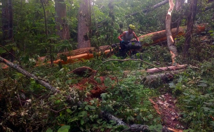
The climb was tough, but not as bad as I was expecting. As a whole, this section of the route was more down than I was expecting, and with the exception of a few large downed trees, we made really good time down to the creek crossing.
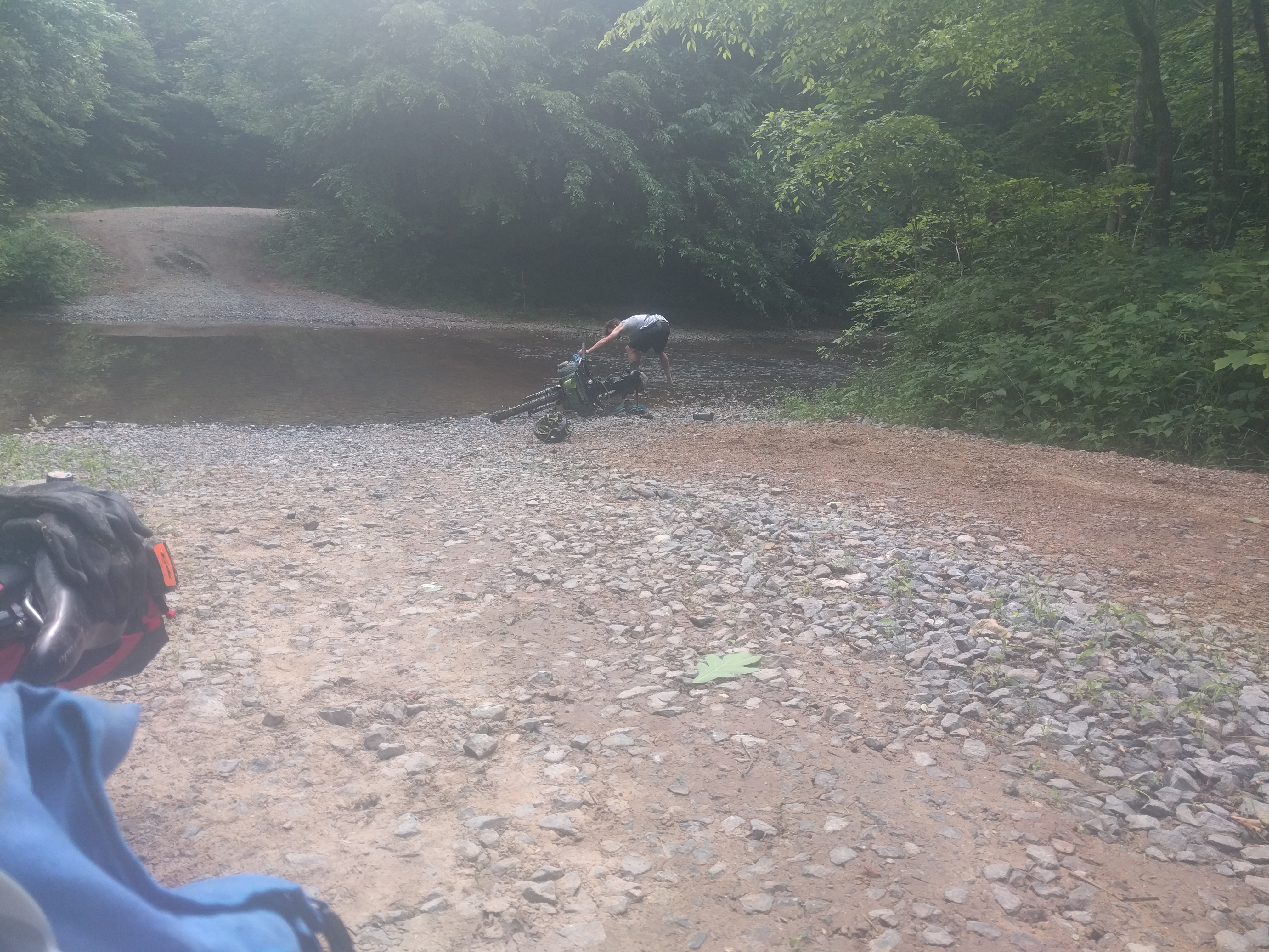
The creek was way down. During the race, the organizers have taken to installing a portable bridge to help keep people [mostly] in the dry. I was able to cross without getting my socks wet at all this time. Of course, right after crossing, I took those socks off and got back in the water to refill all of my bottles. Even going so far as to overstock and fill my Sawyer filter bag. Since this was the end of the route that I had ridden prior to this, I had no knowledge of where there would be water for the rest of the ride. And as most of it seemed to be on top of a ridgeline (not typically a place where water is found), it seemed like a good strategy to top up our bottles whenever the opportunity presented itself.
Topped up with water and freshly refueled with a little bit of trailside breakfast (which we’d skipped due to low water levels at camp), we were off once again.
[The Final Frontier]
Here the route diverts away from the Snake Creek Gap race course and onto some singletrack out to the [main] road. After that, it’s a quick jog on pavement across the valley to the start of the next climb up Strawberry mountain.
Even if it weren’t for the deadfall at multiple places along this climb, it would be a lot of hike-a-bike. The climb seems to go on way longer than it should. It takes advantage of the fact that you’ve ridden almost 300 miles to get here to bring you right to the edge of your sanity, knowing full well that, although you spend a lot of this trail up on the ridge, you do drop down a couple times. These additional quick “dips” proved to be the most psychologically trying part of the whole ride for me.
As we pushed up one of them, the trail turned slightly around some vegetation. Once we pushed around the plants and could see that the climb kept going (in spite of your brains telling us surely we were near the top), I lost it. I began screaming and cursing, at the trail! Kinzer tried to say something encouraging, screw Kinzer. I don’t need encouraging, I need validation! Don’t tell me it’s almost over. It’s clearly not! Tell me you’re also pissed that we’re on bullshit trail, climbing FU mountain.
It was clear I wasn’t the only one starting to crack though. Once we finally got to one of the ridges and were able to get back on the bikes and pedal a little more, we passed a box turtle on the trail and the conversation went:
Kinzer: “Do you ever wonder how he got here?”
Me: “…I imagine he walked.”
Kinzer: “No, like, what’s he doing here?”
Me: “…being a turtle, what else is he going to be doing?”
It’s a shame we were heading towards Alabama where our great philosophical musings would be lost on the general population.
It’s unfortunate that this trail is a) flanked on either side by shitty climbs and b) very remote and not in any way lending to circuity, because the ridge riding is actually pretty nice. The rocks are smaller, more subdued than Snake Creek Gap. The ridge itself is wider and more rounded at the top. Overall it’s actually a decent little trail. The final descent down to the last trailhead is also pretty fun. Even on a loaded bike (which is good because I don’t really see any way that you’d ever ride it not as part of this route).
Finally, we were off the mountains and onto the last stretch of road to the border. Even though you’re completely blasted by this point, just being on the road and knowing that you’re near the finish fills your blood with adrenaline. You can smell the barn. So you start to sprint. Only, it’s still ten miles or so to the finish, so the sprint turns into a tempo ride. Only, you’ve got nothing left in the tank, so the tempo isn’t there. The effort is there, but the results just aren’t. So the joy of being near the end, of at last accomplishing this great feat of endurance, is tainted by the simple fact that it won’t come fast enough!
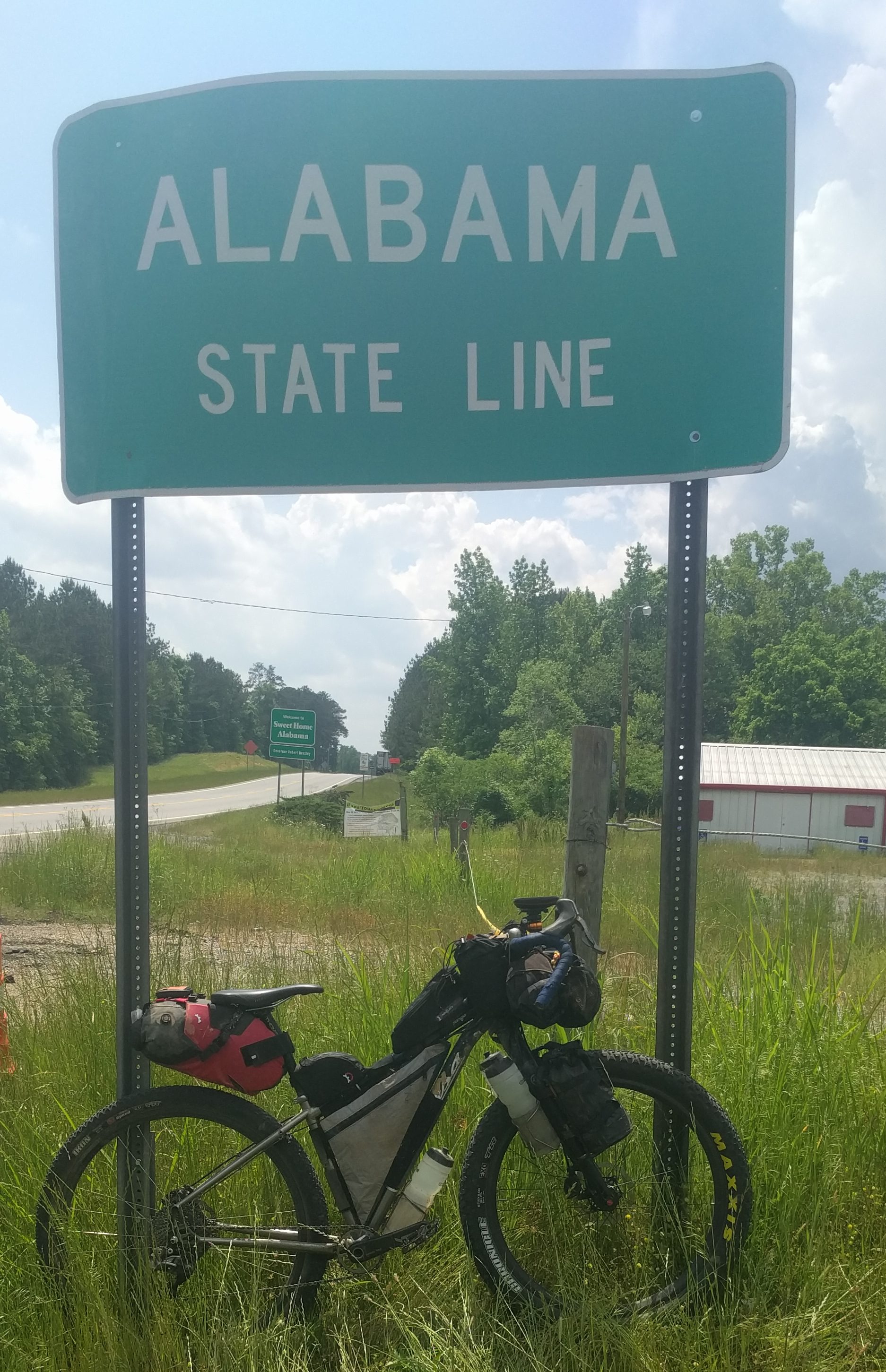
As you turn onto the last road (GA-20), you don’t care that it’s a two-lane, no shoulder road filled with logging trucks. All you care about is that in four miles, there’s a sign, a new state, and the end of this madness.
And for the numbers geeks:
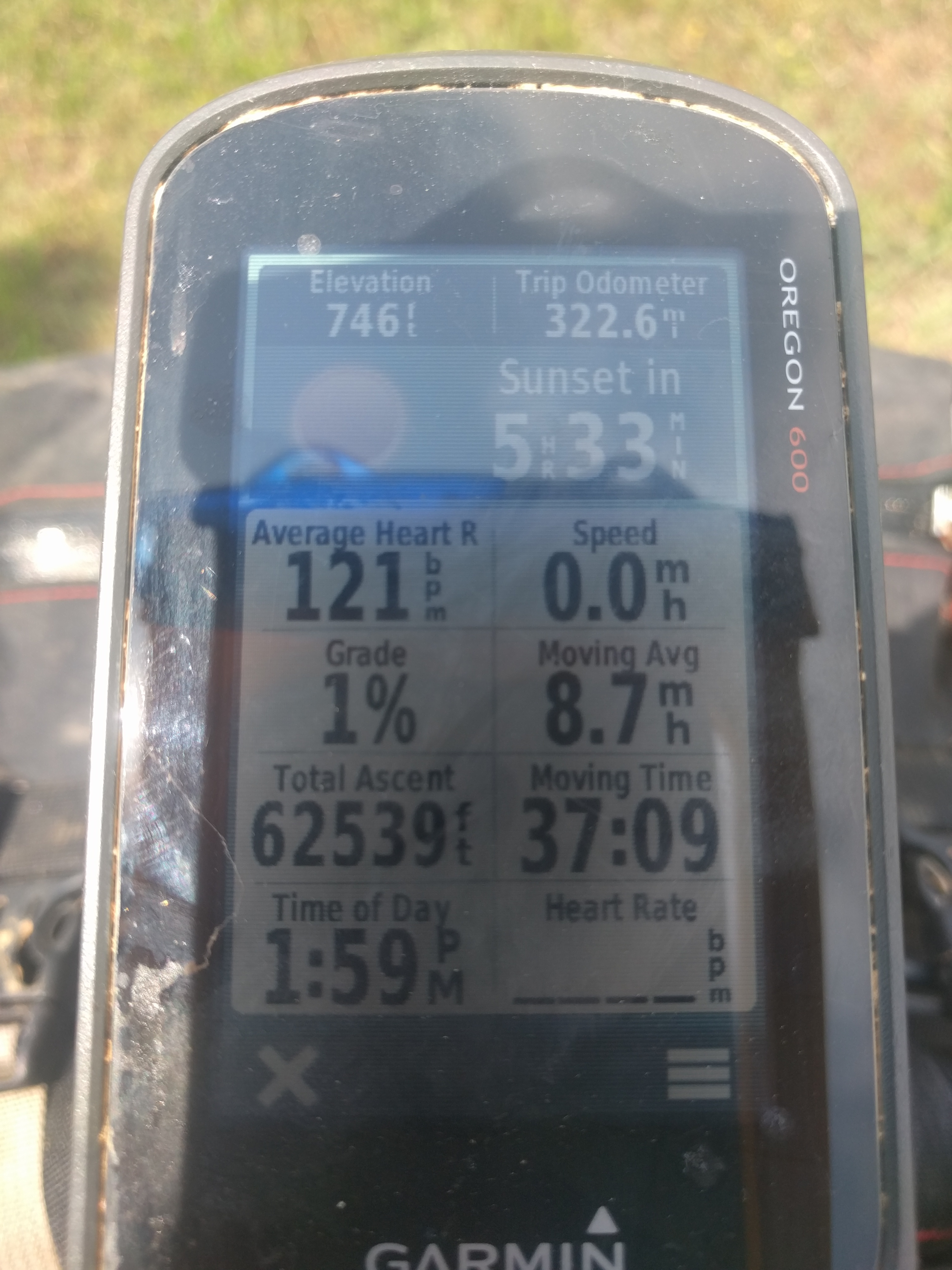
Done. Frickin’ done. Now let’s never speak of it again.
The [4] day’s ride:
[Alabama]
So, our plan was to ride from the border, about 35 miles, down to a campground on the Chief Ladiga Trail, a rails-to-trails trail that mates up with the Silver Comet in GA. We’d camp there and ride home on the Comet the next day. This seemed like a good idea in planning because the roads were mostly flat, appeared fairly remote, and the Comet is rail-grade and free of traffic all the way home.
In reality, we’d just spent 4 miles on GA-20 (now AL-9), on which we’d need to ride another 15-20 miles before turning onto some other “country” road.
I’m not sure if I’ve mentioned this, but I was hosed. Drained. And had no interest in risking my life (remember that phrasing), riding down a highway with no shoulder but lots of logging trucks.
So while we sat at the gas station, catching our breath and slowly allowing our brains to reboot [into SafeMode], I dropped the gem: we just need to wait until an old-timer with an old truck pulls in, we’ll be able to hitch a ride with him to get down this road. I stand by that being an excellent plan. Our execution left something to be desired.
After several newer trucks pulled through, we finally caught our mark: An old Chevy with two [older-looking] guys inside. Kinzer sees the truck pull in, looks at me and says: “I’m gonna ask em”.
Kinzer:”You guys headed to [the next town]?”
Passenger:”{belch} yep” (walks inside the store)
Driver:”(Slams the beer in his hand and tosses the can in the trash) Well, I just was in jail last week, but [unintelligible Alabaman] sure, hop in”
Me (to Kinzer): “Did he just say…?”
Kinzer: “Yep”
So we loaded our bikes in the back of the truck, which was made easy by the fact that there was no tailgate, and hopped in the bed ourselves.
Protip: Don’t make decisions at the end of TNGA. Have a car waiting, or a pre-planned shuttle on its way.
The passenger came out of the store with a fresh 12pack and got in the cab and we were off. I sat with my back to the cab, enjoying the wind and the effortless speed of the ride. Kinzer, who sat on the side of the bed, had a full view of the goings-on in the cabin. Goings-on, which I was alerted to about 4 miles down the road once I heard a loud bang! from the side of the road and caught site of a BudLight bottle ricocheting off a road sign. I gave a glance to Kinzer as if to ask “did he just…?” to which his response was: “That’s his fourth since we left the gas station”… well shit.
Moments later we pulled into the next station down the road, The Weiss Lake Marina, end of the line. It speaks to the level of exhaustion I was experiencing that I’d rather have ridden farther down the road in that truck, than to face the reality of having to get back on my bike. But the choice wasn’t up to me, this was literally the end of the line for this guy. He was dropping his friend off at this spot and was headed back the other way.
So here we were. Kinzer was gearing up to hitchhike some more, but I was over it. I made the decision to go inside, grab a drink and a bite to eat and then I’d call Jessie to come get us.
That decision made, all that was left to do was to make one final headset adjustment and sit in front of this gas station for the next two-and-a-half hours and take in all the glory that is Alabama, where there is clearly no no-shirt-no-shoes policy, nor is there such a thing as DUI (or rather, there is only DUI, but no one seems to care), and a store owner is free to make two six packs by just cutting a 12 pack with a utility knife and selling you six loose beers in half a cardboard box. Ain’t that America?
One thought on “TransNorthGeorgia [Finished]”